
Make a donation
Yahukimo topographic map
Click on the map to display elevation.
Make a donation
Yahukimo
Yahukimo Regency is located in Highland Papua Province, Indonesia. Its geography consists mostly of mountainous areas and highlands. The regency has mountainous terrain and dense forests, with altitudes varying from lowlands to high mountains. This hilly topography makes access to some areas difficult and isolated. In addition, Yahukimo is also crossed by several rivers and has a high diversity of flora and fauna. The climate in this area is generally tropical with quite high rainfall throughout the year.
Make a donation
About this map
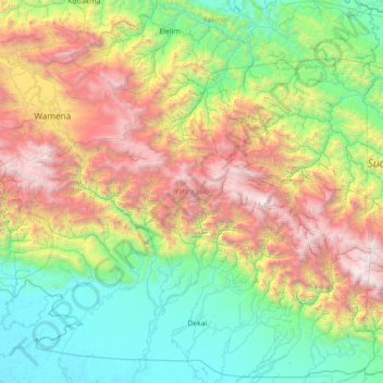
Name: Yahukimo topographic map, elevation, terrain.
Location: Yahukimo, Highland Papua, Western New Guinea, Indonesia (-5.06333 138.73983 -3.68508 140.16270)
Average elevation: 1,320 m
Minimum elevation: 2 m
Maximum elevation: 4,517 m
Make a donation
Other topographic maps
Click on a map to view its topography, its elevation and its terrain.
Make a donation
Wamena
Indonesia > Highland Papua > Jayawijaya
Wamena features a tropical rainforest climate (Köppen Af), albeit a relatively mild version due to its high altitude.
Average elevation: 2,287 m
Make a donation
Make a donation
Make a donation