
Thank you for supporting this site ❤️
Make a donation
Make a donation
Cushing topographic map
Click on the map to display elevation.
Thank you for supporting this site ❤️
Make a donation
Make a donation
About this map
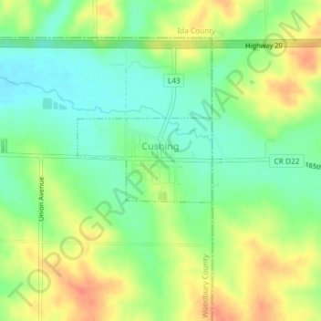
Name: Cushing topographic map, elevation, terrain.
Location: Cushing, Woodbury County, Iowa, United States (42.46099 -95.68458 42.46812 -95.66918)
Average elevation: 402 m
Minimum elevation: 379 m
Maximum elevation: 431 m
Thank you for supporting this site ❤️
Make a donation
Make a donation
Other topographic maps
Click on a map to view its topography, its elevation and its terrain.