
Ghom topographic map
Interactive map
Click on the map to display elevation.
About this map
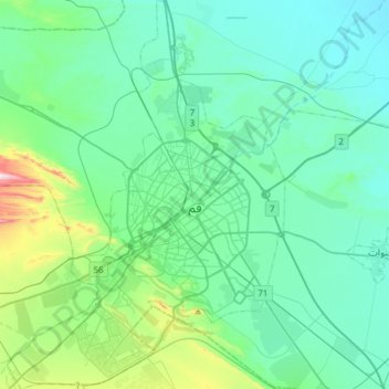
Name: Ghom topographic map, elevation, terrain.
Location: Ghom, بخش مرکزی قم, شهرستان قم, Ghom, Iran (34.52552 50.73317 34.77500 50.95022)
Average elevation: 943 m
Minimum elevation: 846 m
Maximum elevation: 1,440 m
Other topographic maps
Click on a map to view its topography, its elevation and its terrain.
Ghom
Iran > Ghom > شهرستان قم > Ghom
Ghom, شهر قم, بخش مرکزی قم, شهرستان قم, Ghom, 3713744003, Iran
Average elevation: 959 m