
Schwarzberghorn topographic map
Interactive map
Click on the map to display elevation.
About this map
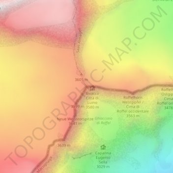
Name: Schwarzberghorn topographic map, elevation, terrain.
Location: Schwarzberghorn, Saas-Almagell, Visp, Vallese, 3905, Svizzera (45.99692 7.90865 45.99702 7.90875)
Average elevation: 3,310 m
Minimum elevation: 2,433 m
Maximum elevation: 3,977 m
Other topographic maps
Click on a map to view its topography, its elevation and its terrain.
Almagellerhorn
Svizzera > Vallese > Saas-Almagell
Almagellerhorn, Saas-Almagell, Visp, Vallese, 3905, Svizzera
Average elevation: 2,703 m
Stausee Mattmark
Svizzera > Vallese > Saas-Almagell
Stausee Mattmark, Ze Seewjine, Saas-Almagell, Visp, Vallese, 3905, Svizzera
Average elevation: 2,452 m
Strahlhorn
Svizzera > Vallese > Saas-Almagell
Strahlhorn, Saas-Almagell, Visp, Vallese, 3905, Svizzera
Average elevation: 3,581 m
Stellihorn
Svizzera > Vallese > Saas-Almagell
Stellihorn, Saas-Almagell, Visp, Vallese, 3905, Svizzera
Average elevation: 2,874 m
Fluchthorn
Svizzera > Vallese > Saas-Almagell
Fluchthorn, Saas-Almagell, Visp, Vallese, 3905, Svizzera
Average elevation: 3,355 m