
Bonner County topographic map
Click on the map to display elevation.
Bonner County
According to the U.S. Census Bureau, the county has a total area of 1,919 square miles (4,970 km2), of which 1,735 square miles (4,490 km2) is land and 185 square miles (480 km2) (9.6%) is water. The highest point in the county is Scotchman Peak, elevation 7,018 feet (2,139 m).
About this map
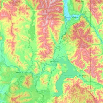
Name: Bonner County topographic map, elevation, terrain.
Location: Bonner County, Idaho, United States (47.88873 -117.04221 48.84707 -116.04867)
Average elevation: 1,052 m
Minimum elevation: 533 m
Maximum elevation: 2,298 m
Other topographic maps
Click on a map to view its topography, its elevation and its terrain.
Boise
United States > Idaho > Ada County > Boise
Boise (/ˈbɔɪsi/ (listen) BOY-see) is the capital and most populous city of the U.S. state of Idaho and is the county seat of Ada County. On the Boise River in southwestern Idaho, it is 41 miles (66 km) east of the Oregon border and 110 miles (177 km) north of the Nevada border. The downtown area's elevation…
Average elevation: 1,040 m