
Thank you for supporting this site ❤️
Make a donation
Make a donation
Niederhagen topographic map
Click on the map to display elevation.
Thank you for supporting this site ❤️
Make a donation
Make a donation
About this map
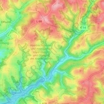
Name: Niederhagen topographic map, elevation, terrain.
Average elevation: 250 m
Minimum elevation: 181 m
Maximum elevation: 320 m
Thank you for supporting this site ❤️
Make a donation
Make a donation
Other topographic maps
Click on a map to view its topography, its elevation and its terrain.
42929
Deutschland > Nordrhein-Westfalen > Rheinisch-Bergischer Kreis > Wermelskirchen > Finkenholl
Average elevation: 243 m