
Much topographic map
Interactive map
Click on the map to display elevation.
About this map
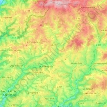
Name: Much topographic map, elevation, terrain.
Location: Much, Rhein-Sieg-Kreis, Noordrijn-Westfalen, 53804, Duitsland (50.84143 7.30311 50.94970 7.47930)
Average elevation: 227 m
Minimum elevation: 99 m
Maximum elevation: 380 m
Other topographic maps
Click on a map to view its topography, its elevation and its terrain.
Bad Honnef
Duitsland > Noordrijn-Westfalen > Rhein-Sieg-Kreis > Bad Honnef
Bad Honnef, Rhein-Sieg-Kreis, Noordrijn-Westfalen, 53604, Duitsland
Average elevation: 182 m
Rheinbach
Duitsland > Noordrijn-Westfalen > Rhein-Sieg-Kreis > Rheinbach
Rheinbach, Rhein-Sieg-Kreis, Noordrijn-Westfalen, 53359, Duitsland
Average elevation: 232 m
Geistingen
Duitsland > Noordrijn-Westfalen > Rhein-Sieg-Kreis > Hennef (Sieg)
Geistingen, Hennef (Sieg), Rhein-Sieg-Kreis, Noordrijn-Westfalen, Duitsland
Average elevation: 102 m
Meckenheim
Duitsland > Noordrijn-Westfalen > Rhein-Sieg-Kreis
Meckenheim, Rhein-Sieg-Kreis, Noordrijn-Westfalen, 53340, Duitsland
Average elevation: 208 m