
Java Central topographic map
Interactive map
Click on the map to display elevation.
About this map
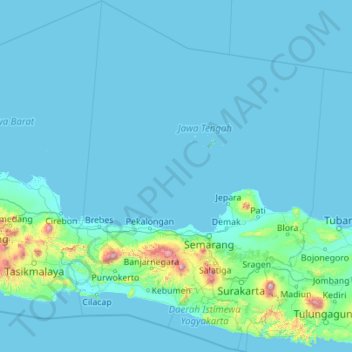
Name: Java Central topographic map, elevation, terrain.
Location: Java Central, Indonesia (-8.44119 108.55585 -4.03879 111.86897)
Average elevation: 78 m
Minimum elevation: -2 m
Maximum elevation: 3,247 m
Other topographic maps
Click on a map to view its topography, its elevation and its terrain.
Surakarta
Indonesia > Java Central > Surakarta
Surakarta, Kecamatan Pasar Kliwon, Java Central, Indonesia
Average elevation: 102 m
Purwokerto
Indonesia > Java Central > Purwokerto
Purwokerto, Banyumas, Java Central, 53116, Indonesia
Average elevation: 277 m