
Thank you for supporting this site ❤️
Make a donation
Make a donation
West Orange topographic map
Click on the map to display elevation.
Thank you for supporting this site ❤️
Make a donation
Make a donation
About this map
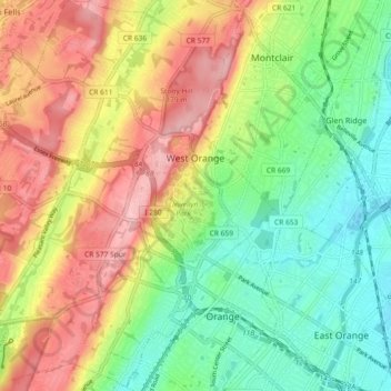
Name: West Orange topographic map, elevation, terrain.
Location: West Orange, Essex County, New Jersey, 07052, United States (40.75739 -74.30505 40.82656 -74.22089)
Average elevation: 108 m
Minimum elevation: 34 m
Maximum elevation: 202 m
Thank you for supporting this site ❤️
Make a donation
Make a donation
Other topographic maps
Click on a map to view its topography, its elevation and its terrain.
Short Hills
United States > New Jersey > Essex County > Millburn > Short Hills
Average elevation: 98 m