
Kalaymyo topographic map
Interactive map
Click on the map to display elevation.
About this map
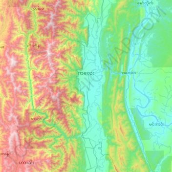
Name: Kalaymyo topographic map, elevation, terrain.
Location: Kalaymyo, ကလေးခရိုင်, Région de Sagaing, Birmanie (22.58301 93.94319 23.65608 94.27883)
Average elevation: 741 m
Minimum elevation: 80 m
Maximum elevation: 2,666 m
Other topographic maps
Click on a map to view its topography, its elevation and its terrain.
ကျောက်မြောင်း
Birmanie > Région de Sagaing > Shwebo
ကျောက်မြောင်း, Shwebo, ရွှေဘိုခရိုင်, Région de Sagaing, Birmanie
Average elevation: 99 m
လုံဝသင်္ခ
Birmanie > Région de Sagaing > လုံဝသင်္ခ
လုံဝသင်္ခ, နာဂ ကိုယ်ပိုင်အုပ်ချုပ်ခွင့်ရ ဒေသ, ခန္တီးခရိုင်, Région de Sagaing, Birmanie
Average elevation: 1,181 m
Lower Chindwin
Birmanie > Région de Sagaing > ကနီ
Lower Chindwin, ကနီ, ယင်းမာပင်ခရိုင်, Région de Sagaing, Birmanie
Average elevation: 117 m