
Rhydcymerau topographic map
Interactive map
Click on the map to display elevation.
About this map
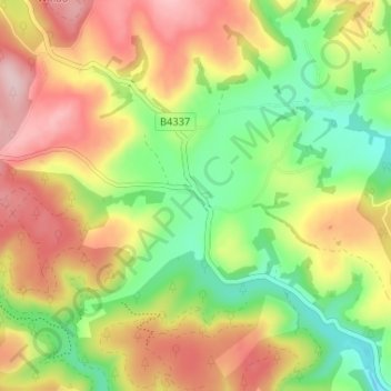
Name: Rhydcymerau topographic map, elevation, terrain.
Average elevation: 256 m
Minimum elevation: 147 m
Maximum elevation: 376 m
Other topographic maps
Click on a map to view its topography, its elevation and its terrain.
Pumsaint
United Kingdom > Wales > Carmarthenshire
Pumsaint, Carmarthenshire, Wales, SA19 8YT, United Kingdom
Average elevation: 181 m
Carmarthen
United Kingdom > Wales > Carmarthenshire > Carmarthen
Carmarthen, Carmarthenshire, Wales, SA31 1RT, United Kingdom
Average elevation: 74 m