
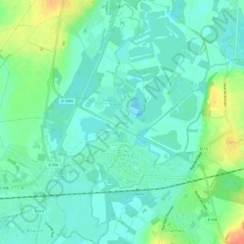
La Fère topographic map
Interactive map
Click on the map to display elevation.
About this map
Name: La Fère topographic map, elevation, terrain.
Average elevation: 56 m
Minimum elevation: 42 m
Maximum elevation: 90 m
Other topographic maps
Click on a map to view its topography, its elevation and its terrain.
Menneville
France > Hauts-de-France > Aisne > Villeneuve-sur-Aisne
Menneville, Villeneuve-sur-Aisne, Laon, Aisne, Hauts-de-France, France métropolitaine, 02190, France
Average elevation: 76 m
Gomont
France > Hauts-de-France > Aisne > Marly-Gomont
Gomont, Marly-Gomont, Vervins, Aisne, Hauts-de-France, France métropolitaine, 02120, France
Average elevation: 147 m
Rocquigny
France > Hauts-de-France > Aisne
Rocquigny, Vervins, Aisne, Hauts-de-France, France métropolitaine, 02260, France
Average elevation: 192 m
Braine
France > Hauts-de-France > Aisne
Braine, Soissons, Aisne, Hauts-de-France, France métropolitaine, 02220, France
Average elevation: 86 m
Chassemy
France > Hauts-de-France > Aisne
Chassemy, Soissons, Aisne, Hauts-de-France, France métropolitaine, 02370, France
Average elevation: 72 m
Celles-lès-Condé
France > Hauts-de-France > Aisne
Celles-lès-Condé, Château-Thierry, Aisne, Hauts-de-France, France métropolitaine, 02330, France
Average elevation: 135 m
Leuze
France > Hauts-de-France > Aisne
Leuze, Vervins, Aisne, Hauts-de-France, France métropolitaine, 02500, France
Average elevation: 196 m
Fontenoy
France > Hauts-de-France > Aisne
Fontenoy, Soissons, Aisne, Hauts-de-France, France métropolitaine, 02290, France
Average elevation: 81 m
Gouy
France > Hauts-de-France > Aisne
Gouy, Saint-Quentin, Aisne, Hauts-de-France, France métropolitaine, 02420, France
Average elevation: 121 m
Gauchy
France > Hauts-de-France > Aisne > Gauchy
Gauchy, Saint-Quentin, Aisne, Hauts-de-France, France métropolitaine, 02430, France
Average elevation: 88 m