
Xerta topographic map
Interactive map
Click on the map to display elevation.
About this map
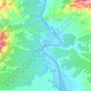
Name: Xerta topographic map, elevation, terrain.
Location: Xerta, Baix Ebre, Tarragona, Catalonië, 43592, Spanje (40.86112 0.41661 40.94613 0.50979)
Average elevation: 124 m
Minimum elevation: 2 m
Maximum elevation: 644 m
Other topographic maps
Click on a map to view its topography, its elevation and its terrain.
el Perelló
Spanje > Catalonië > Baix Ebre
el Perelló, Baix Ebre, Tarragona, Catalonië, 43519, Spanje
Average elevation: 166 m