
Make a donation
Greenstone topographic map
Click on the map to display elevation.
Make a donation
About this map
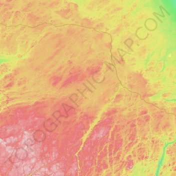
Name: Greenstone topographic map, elevation, terrain.
Average elevation: 351 m
Minimum elevation: 214 m
Maximum elevation: 554 m
Make a donation
Other topographic maps
Click on a map to view its topography, its elevation and its terrain.
Kashabowie
Canada > Ontario > Thunder Bay District > Unorganized Thunder Bay District
Average elevation: 467 m
Stoney Creek
Canada > Ontario > Thunder Bay District > Unorganized Thunder Bay District
Average elevation: 367 m
Make a donation
Ombabika River
Canada > Ontario > Thunder Bay District > Unorganized Thunder Bay District
Average elevation: 311 m
Ara Lake
Canada > Ontario > Thunder Bay District > Unorganized Thunder Bay District
Average elevation: 308 m
Ara Island
Canada > Ontario > Thunder Bay District > Unorganized Thunder Bay District
Average elevation: 305 m
Pringle
Canada > Ontario > Thunder Bay District > Unorganized Thunder Bay District
Average elevation: 289 m
Make a donation