
Make a donation
Gold Hill topographic map
Click on the map to display elevation.
Make a donation
About this map
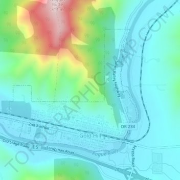
Name: Gold Hill topographic map, elevation, terrain.
Location: Gold Hill, Jackson County, Oregon, United States (42.42940 -123.07284 42.44771 -123.04083)
Average elevation: 416 m
Minimum elevation: 315 m
Maximum elevation: 791 m
Make a donation
Other topographic maps
Click on a map to view its topography, its elevation and its terrain.
Mount McLoughlin
United States > Oregon > Jackson County
The major landmark for the Rogue River Valley, Mount McLoughlin reaches an elevation of 9,493 ft (2,893 m). The tallest volcano in between Mount Shasta — located 70 mi (110 km) to the south — and South Sister 120 miles (190 km) to the north, it lies in the Cascade Range, in the southern portion of the U.S.…
Average elevation: 2,296 m
Make a donation
Make a donation
Siskiyou Gap
United States > Oregon > Jackson County
"The original pass crosses the divide between the Rogue and Klamath Rivers at a slight topographic notch formed by the geological contact between the older Siskiyou Mountains to the west and the younger volcanic Cascade Range to the east." (Jeffrey M. LaLande, retired, forest archaeologist, Rogue…
Average elevation: 1,746 m
Make a donation