
Moléson topographic map
Interactive map
Click on the map to display elevation.
About this map
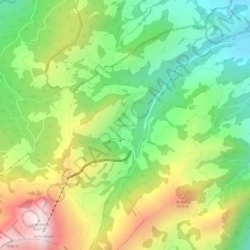
Name: Moléson topographic map, elevation, terrain.
Location: Moléson, Gruyères, Greyerzbezirk, Freiburg, 1663, Schweiz (46.54420 7.01711 46.58420 7.05711)
Average elevation: 1,256 m
Minimum elevation: 769 m
Maximum elevation: 1,976 m
Other topographic maps
Click on a map to view its topography, its elevation and its terrain.
Bulle
Schweiz > Freiburg > Greyerzbezirk
Bulle, Greyerzbezirk, Freiburg, Schweiz
Average elevation: 834 m