
Thank you for supporting this site ❤️
Make a donation
Make a donation
Gatow topographic map
Click on the map to display elevation.
Thank you for supporting this site ❤️
Make a donation
Make a donation
About this map
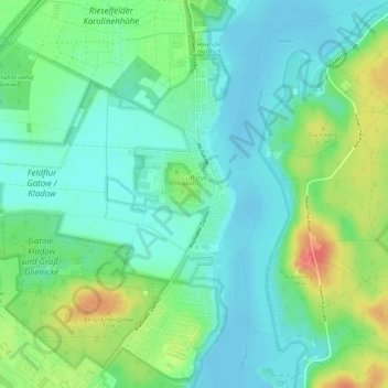
Name: Gatow topographic map, elevation, terrain.
Location: Gatow, Spandau, Berlín, Alemania (52.46655 13.13555 52.50162 13.19171)
Average elevation: 44 m
Minimum elevation: 27 m
Maximum elevation: 81 m
Thank you for supporting this site ❤️
Make a donation
Make a donation
Other topographic maps
Click on a map to view its topography, its elevation and its terrain.