
Thank you for supporting this site ❤️
Make a donation
Make a donation
Ban Den topographic map
Click on the map to display elevation.
Thank you for supporting this site ❤️
Make a donation
Make a donation
About this map
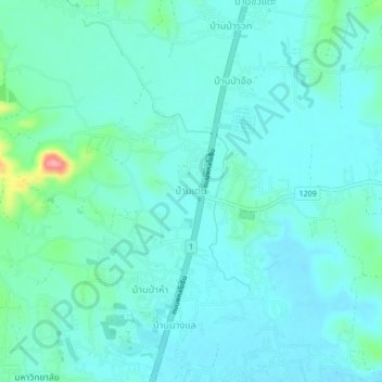
Name: Ban Den topographic map, elevation, terrain.
Location: Ban Den, Nang Lae, Chiang Rai Province, 57100, Thailand (19.98480 99.84607 20.02480 99.88607)
Average elevation: 401 m
Minimum elevation: 383 m
Maximum elevation: 494 m
Thank you for supporting this site ❤️
Make a donation
Make a donation
Other topographic maps
Click on a map to view its topography, its elevation and its terrain.