
Thank you for supporting this site ❤️
Make a donation
Make a donation
Kampung Periuk topographic map
Click on the map to display elevation.
Thank you for supporting this site ❤️
Make a donation
Make a donation
About this map
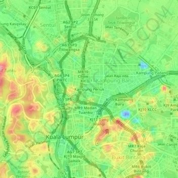
Name: Kampung Periuk topographic map, elevation, terrain.
Location: Kampung Periuk, Kampong Bharu, Kuala Lumpur, 50300, Malaysia (3.14238 101.67977 3.18238 101.71977)
Average elevation: 47 m
Minimum elevation: -52 m
Maximum elevation: 106 m
Thank you for supporting this site ❤️
Make a donation
Make a donation
Other topographic maps
Click on a map to view its topography, its elevation and its terrain.