
Thank you for supporting this site ❤️
Make a donation
Make a donation
Borriol topographic map
Click on the map to display elevation.
Thank you for supporting this site ❤️
Make a donation
Make a donation
About this map
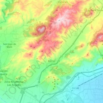
Name: Borriol topographic map, elevation, terrain.
Average elevation: 250 m
Minimum elevation: -1 m
Maximum elevation: 724 m
Thank you for supporting this site ❤️
Make a donation
Make a donation
Other topographic maps
Click on a map to view its topography, its elevation and its terrain.
Vila-real
Espanha > Comunidade Valenciana > Castelló / Castellón > Vila-real > Vila-real
Average elevation: 42 m
Parque de La Floresta
Espanha > Comunidade Valenciana > Castelló / Castellón > Viver
Average elevation: 592 m