
Thank you for supporting this site ❤️
Make a donation
Make a donation
Gargoulet topographic map
Click on the map to display elevation.
Thank you for supporting this site ❤️
Make a donation
Make a donation
About this map
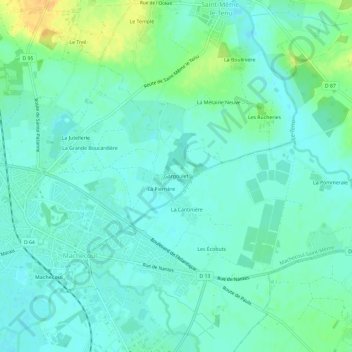
Name: Gargoulet topographic map, elevation, terrain.
Average elevation: 9 m
Minimum elevation: 0 m
Maximum elevation: 30 m
Thank you for supporting this site ❤️
Make a donation
Make a donation
Other topographic maps
Click on a map to view its topography, its elevation and its terrain.
Saint-Même-le-Tenu
France > Pays de la Loire > Loire-Atlantique > Machecoul-Saint-Même
Average elevation: 21 m