
Feldmeilen topographic map
Interactive map
Click on the map to display elevation.
About this map
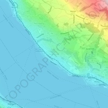
Name: Feldmeilen topographic map, elevation, terrain.
Location: Feldmeilen, Meilen, Bezirk Meilen, Zürich, 8706, Schweiz (47.25917 8.60075 47.29917 8.64075)
Average elevation: 471 m
Minimum elevation: 401 m
Maximum elevation: 803 m
Other topographic maps
Click on a map to view its topography, its elevation and its terrain.
Toggwil
Schweiz > Zürich > Bezirk Meilen > Meilen > Bergmeilen > Toggwil
Toggwil, Bergmeilen, Meilen, Bezirk Meilen, Zürich, 8706, Schweiz
Average elevation: 634 m