
Barjac topographic map
Interactive map
Click on the map to display elevation.
About this map
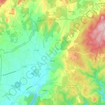
Name: Barjac topographic map, elevation, terrain.
Average elevation: 206 m
Minimum elevation: 113 m
Maximum elevation: 367 m
Other topographic maps
Click on a map to view its topography, its elevation and its terrain.
Gallargues-le-Montueux
Gallargues-le-Montueux, Nîmes, Gard, Occitania, Francia metropolitana, 30660, Francia
Average elevation: 19 m
Pont de Rastel
Francia > Occitania > Gard > Génolhac
Pont de Rastel, Génolhac, Alès, Gard, Occitania, Francia metropolitana, 30450, Francia
Average elevation: 422 m
Fond Granade
Francia > Occitania > Gard > Lédignan
Fond Granade, Lédignan, Le Vigan, Gard, Occitania, Francia metropolitana, 30350, Francia
Average elevation: 131 m