
Desert Mountain topographic map
Interactive map
Click on the map to display elevation.
About this map
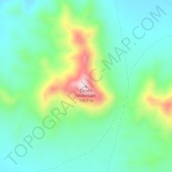
Name: Desert Mountain topographic map, elevation, terrain.
Location: Desert Mountain, Juab County, Utah, United States (39.78129 -112.59417 39.78139 -112.59407)
Average elevation: 1,673 m
Minimum elevation: 1,563 m
Maximum elevation: 1,953 m
Other topographic maps
Click on a map to view its topography, its elevation and its terrain.
Eureka
United States > Utah > Juab County
Eureka, Juab County, Utah, United States
Average elevation: 2,048 m
Topaz Mountain
United States > Utah > Juab County
Topaz Mountain, Juab County, Utah, United States
Average elevation: 1,895 m
Nephi
United States > Utah > Juab County > Nephi
Nephi, Juab County, Utah, 84648, United States
Average elevation: 1,651 m
Nephi
United States > Utah > Juab County
Nephi, Juab County, Utah, 84648, United States
Average elevation: 1,637 m