
Nußdorf topographic map
Interactive map
Click on the map to display elevation.
About this map
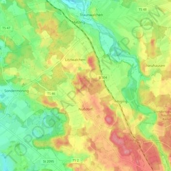
Name: Nußdorf topographic map, elevation, terrain.
Location: Nußdorf, Landkreis Traunstein, Bayern, 83365, Deutschland (47.89033 12.54279 47.93818 12.63516)
Average elevation: 571 m
Minimum elevation: 526 m
Maximum elevation: 625 m
Other topographic maps
Click on a map to view its topography, its elevation and its terrain.
Ischl
Deutschland > Bayern > Landkreis Traunstein > Seeon-Seebruck
Ischl, Seeon-Seebruck, Landkreis Traunstein, Bayern, 83370, Deutschland
Average elevation: 534 m
Assing
Deutschland > Bayern > Landkreis Traunstein > Taching am See > Assing
Assing, Taching am See, Waging am See (VGem), Landkreis Traunstein, Bayern, 83373, Deutschland
Average elevation: 517 m
Chiemsee
Deutschland > Bayern > Landkreis Traunstein > Chiemsee
Chiemsee, Breitbrunn am Chiemsee (VGem), Landkreis Traunstein, Bayern, Deutschland
Average elevation: 527 m