
Thank you for supporting this site ❤️
Make a donation
Make a donation
Tsonevo topographic map
Click on the map to display elevation.
Thank you for supporting this site ❤️
Make a donation
Make a donation
About this map
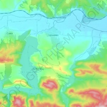
Name: Tsonevo topographic map, elevation, terrain.
Location: Tsonevo, Dalgopol, Varna, Bulgaria (42.97274 27.36451 43.05200 27.50632)
Average elevation: 108 m
Minimum elevation: 21 m
Maximum elevation: 402 m
Thank you for supporting this site ❤️
Make a donation
Make a donation
Other topographic maps
Click on a map to view its topography, its elevation and its terrain.