
Gila County topographic map
Interactive map
Click on the map to display elevation.
About this map
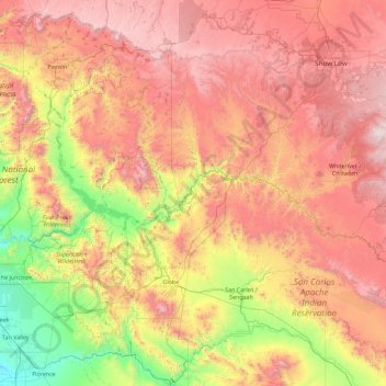
Name: Gila County topographic map, elevation, terrain.
Location: Gila County, Arizona, United States of America (32.98367 -111.72090 34.49911 -110.00031)
Average elevation: 1,361 m
Minimum elevation: 390 m
Maximum elevation: 2,449 m
Other topographic maps
Click on a map to view its topography, its elevation and its terrain.
Gilbert
United States of America > Arizona > Gilbert
Gilbert, Maricopa County, Arizona, 85269, United States of America
Average elevation: 400 m
Bright Angel Point
United States of America > Arizona > North Rim
Bright Angel Point, Bright Angel Point Trail, North Rim, Coconino County, Arizona, United States of America
Average elevation: 1,910 m
Pinal County
United States of America > Arizona
Pinal County, Arizona, United States of America
Average elevation: 729 m
Pima County
United States of America > Arizona
Pima County, Arizona, United States of America
Average elevation: 807 m
Casa Grande
United States of America > Arizona > Casa Grande
Casa Grande, Pinal County, Arizona, United States of America
Average elevation: 439 m