
Thank you for supporting this site ❤️
Make a donation
Make a donation
West Pelzer topographic map
Click on the map to display elevation.
Thank you for supporting this site ❤️
Make a donation
Make a donation
About this map
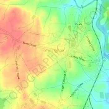
Name: West Pelzer topographic map, elevation, terrain.
Location: West Pelzer, Anderson County, South Carolina, United States (34.63799 -82.48184 34.64948 -82.46551)
Average elevation: 249 m
Minimum elevation: 216 m
Maximum elevation: 278 m
Thank you for supporting this site ❤️
Make a donation
Make a donation
Other topographic maps
Click on a map to view its topography, its elevation and its terrain.
Thank you for supporting this site ❤️
Make a donation
Make a donation
Thank you for supporting this site ❤️
Make a donation
Make a donation
Pendleton Gardens
United States > South Carolina > Anderson County > Pendleton
Average elevation: 240 m
Thank you for supporting this site ❤️
Make a donation
Make a donation
Thank you for supporting this site ❤️
Make a donation
Make a donation
Sweet Gum Trail
United States > South Carolina > Anderson County > Sweet Gum Trail
Average elevation: 227 m
Huntington Hills
United States > South Carolina > Anderson County > Huntington Hills
Average elevation: 236 m
Thank you for supporting this site ❤️
Make a donation
Make a donation