
Thank you for supporting this site ❤️
Make a donation
Make a donation
Nitrianske Pravno topographic map
Click on the map to display elevation.
Thank you for supporting this site ❤️
Make a donation
Make a donation
Nitrianske Pravno
The municipality lies at an altitude of 348 metres (1142 feet) and covers an area of 31.195 km² (12.045 mi²). It has a population of about 3,180 people. The municipality lies in the upper Nitra River valley region, 12 km north of Prievidza.
Thank you for supporting this site ❤️
Make a donation
Make a donation
About this map
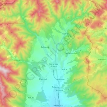
Name: Nitrianske Pravno topographic map, elevation, terrain.
Average elevation: 566 m
Minimum elevation: 292 m
Maximum elevation: 1,068 m
Thank you for supporting this site ❤️
Make a donation
Make a donation
Other topographic maps
Click on a map to view its topography, its elevation and its terrain.
Gápel
Slovakia > Region of Trenčín > District of Prievidza > Valaská Belá > Gápel
Average elevation: 652 m
Prievidza
Slovakia > Region of Trenčín > District of Prievidza > Prievidza > Prievidza
Average elevation: 332 m