
Düdingen topographic map
Interactive map
Click on the map to display elevation.
About this map
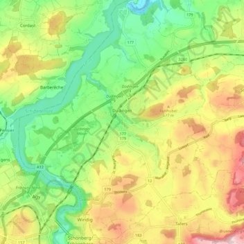
Name: Düdingen topographic map, elevation, terrain.
Location: Düdingen, Sensebezirk, Freiburg, 3186, Schweiz (46.80905 7.14433 46.88324 7.23216)
Average elevation: 618 m
Minimum elevation: 491 m
Maximum elevation: 791 m
Other topographic maps
Click on a map to view its topography, its elevation and its terrain.
Wünnewil-Flamatt
Schweiz > Freiburg > Sensebezirk > Wünnewil
Wünnewil-Flamatt, Wünnewil, Sensebezirk, Freiburg, 3184, Schweiz
Average elevation: 610 m
Plasselb
Schweiz > Freiburg > Sensebezirk > Plasselb
Plasselb, Sensebezirk, Freiburg, 1737, Schweiz
Average elevation: 1,127 m