
Yanahuara topographic map
Interactive map
Click on the map to display elevation.
About this map
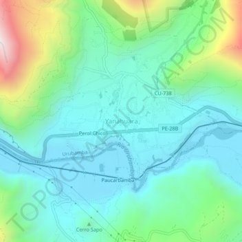
Name: Yanahuara topographic map, elevation, terrain.
Location: Yanahuara, Urubamba, Cusco, 08660, Perú (-13.29627 -72.20633 -13.25627 -72.16633)
Average elevation: 3,089 m
Minimum elevation: 2,813 m
Maximum elevation: 3,970 m
Other topographic maps
Click on a map to view its topography, its elevation and its terrain.
Chichubamba
Chichubamba, Urubamba, Cusco, 08661, Perú
Average elevation: 3,124 m