
Make a donation
Hainan Island topographic map
Click on the map to display elevation.
Make a donation
Hainan Island
Even while Hainan Island was a part of Guangdong it had a considerable amount of local autonomy; the southern half of the island was an autonomous prefecture. Hainan's elevation to provincial level in 1988 increased its accountability to the Central People's Government, but by designating the new province a special economic zone the central government expressed its intent to allow Hainan maximum flexibility in devising programs to facilitate foreign investment and economic growth. Administratively, the province has been divided into five economic major districts.
Make a donation
About this map
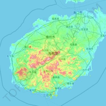
Name: Hainan Island topographic map, elevation, terrain.
Location: Hainan Island, Hainan Province, China (18.15920 108.61254 20.16251 111.04233)
Average elevation: 98 m
Minimum elevation: -3 m
Maximum elevation: 1,768 m
Make a donation
Other topographic maps
Click on a map to view its topography, its elevation and its terrain.
Scarborough Shoal
China > Hainan Province > Sansha
The Philippines state that its assertion of sovereignty over the atoll is based on the juridical criteria established by public international law on the lawful methods for the acquisition of sovereignty. Among the criteria (effective occupation, cession, prescription, conquest, and accretion), the Philippine…
Average elevation: 0 m
Mischief Reef
China > Hainan Province > Sansha
Mischief Reef, also known as Panganiban Reef (Tagalog: Bahura ng Panganiban; Vietnamese: Đá Vành Khăn; Mandarin Chinese: 美濟礁/美济礁; pinyin: Měijì Jiāo; lit. 'Meiji Reef'), is a low tide elevation (LTE) reef/atoll surrounding a large lagoon in the SE of Dangerous Ground in the east of the…
Average elevation: 0 m
Subi Reef
China > Hainan Province > Nansha District
On 12 July 2016, the UNCLOS special arbitral tribunal in the Philippines v. China case confirmed that Subi Reef is, or in its natural condition was, exposed at low tide and submerged at high tide and is, accordingly a low-tide elevation that does not generate entitlement to a territorial sea, exclusive…
Average elevation: 0 m
Make a donation
Wuzhi Mountain
China > Hainan Province > Qiongzhong Li and Miao Autonomous County
Average elevation: 1,217 m