
Thank you for supporting this site ❤️
Make a donation
Make a donation
Dogtown topographic map
Click on the map to display elevation.
Thank you for supporting this site ❤️
Make a donation
Make a donation
About this map
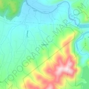
Name: Dogtown topographic map, elevation, terrain.
Location: Dogtown, Carter County, Tennessee, United States (36.31261 -82.16485 36.35261 -82.12485)
Average elevation: 617 m
Minimum elevation: 475 m
Maximum elevation: 953 m
Thank you for supporting this site ❤️
Make a donation
Make a donation
Other topographic maps
Click on a map to view its topography, its elevation and its terrain.