
Sandgate topographic map
Interactive map
Click on the map to display elevation.
About this map
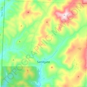
Name: Sandgate topographic map, elevation, terrain.
Location: Sandgate, Bennington County, Vermont, United States (43.12046 -73.26410 43.21703 -73.13014)
Average elevation: 480 m
Minimum elevation: 193 m
Maximum elevation: 1,002 m
Other topographic maps
Click on a map to view its topography, its elevation and its terrain.
Manchester
United States > Vermont > Bennington County
Manchester, Bennington County, Vermont, United States
Average elevation: 452 m