
1st district topographic map
Interactive map
Click on the map to display elevation.
About this map
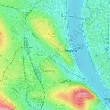
Name: 1st district topographic map, elevation, terrain.
Location: 1st district, Budapest, Central Hungary, Hungary (47.48567 19.02376 47.50807 19.05131)
Average elevation: 137 m
Minimum elevation: 97 m
Maximum elevation: 228 m
Other topographic maps
Click on a map to view its topography, its elevation and its terrain.
7th district
7th district, Budapest, Central Hungary, Hungary
Average elevation: 115 m
Háros-sziget
Háros-sziget, Budapest, Central Hungary, 1777, Hungary
Average elevation: 159 m
2nd district
2nd district, Budapest, Central Hungary, Hungary
Average elevation: 252 m
3rd district
3rd district, Budapest, Central Hungary, Hungary
Average elevation: 164 m
11th district
11th district, Budapest, Central Hungary, Hungary
Average elevation: 139 m
14th district
14th district, Budapest, Central Hungary, Hungary
Average elevation: 116 m
5th district
5th district, Budapest, Central Hungary, Hungary
Average elevation: 122 m
21st district
21st district, Budapest, Central Hungary, Hungary
Average elevation: 110 m
22nd district
22nd district, Budapest, Central Hungary, Hungary
Average elevation: 126 m
Budaörsi-árok
Budaörsi-árok, Budapest, Central Hungary, 2040, Hungary
Average elevation: 141 m
Angyal István park
Angyal István park, Belső-Ferencváros, 9th district, Budapest, Central Hungary, 1092, Hungary
Average elevation: 113 m
Gárdonyi tér
Gárdonyi tér, 31, Lágymányos, 11th district, Budapest, Central Hungary, 1111, Hungary
Average elevation: 119 m
Nagytétény
Nagytétény, 22nd district, Budapest, Central Hungary, Hungary
Average elevation: 127 m