
Bad Düben topographic map
Interactive map
Click on the map to display elevation.
About this map
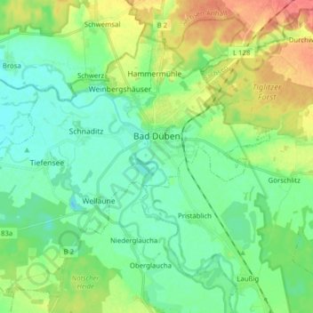
Name: Bad Düben topographic map, elevation, terrain.
Location: Bad Düben, Nordsachsen, Sachsen, 04849, Deutschland (51.54128 12.48777 51.62795 12.64360)
Average elevation: 98 m
Minimum elevation: 81 m
Maximum elevation: 134 m
Other topographic maps
Click on a map to view its topography, its elevation and its terrain.
Zschepplin
Deutschland > Sachsen > Nordsachsen
Zschepplin, Eilenburg-West, Nordsachsen, Sachsen, Deutschland
Average elevation: 102 m
Schkeuditz
Deutschland > Sachsen > Nordsachsen > Schkeuditz
Schkeuditz, Nordsachsen, Sachsen, 04435, Deutschland
Average elevation: 116 m