
Thank you for supporting this site ❤️
Make a donation
Make a donation
Mason County topographic map
Click on the map to display elevation.
Thank you for supporting this site ❤️
Make a donation
Make a donation
About this map
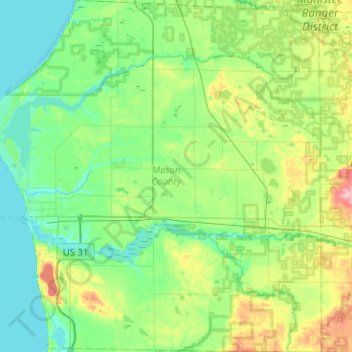
Name: Mason County topographic map, elevation, terrain.
Location: Mason County, Michigan, United States (43.81548 -86.51540 44.17876 -86.03785)
Average elevation: 210 m
Minimum elevation: 174 m
Maximum elevation: 331 m
Thank you for supporting this site ❤️
Make a donation
Make a donation
Other topographic maps
Click on a map to view its topography, its elevation and its terrain.
North Ottawa Dunes County Park
United States > Michigan > Ottawa County > Ferrysburg
Average elevation: 188 m
Thank you for supporting this site ❤️
Make a donation
Make a donation