
Thank you for supporting this site ❤️
Make a donation
Make a donation
Karukodi topographic map
Click on the map to display elevation.
Thank you for supporting this site ❤️
Make a donation
Make a donation
About this map
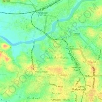
Name: Karukodi topographic map, elevation, terrain.
Location: Karukodi, Palakkad, Kerala, 678012, India (10.76319 76.62097 10.80319 76.66097)
Average elevation: 85 m
Minimum elevation: 66 m
Maximum elevation: 107 m
Thank you for supporting this site ❤️
Make a donation
Make a donation
Other topographic maps
Click on a map to view its topography, its elevation and its terrain.
Thank you for supporting this site ❤️
Make a donation
Make a donation
Thank you for supporting this site ❤️
Make a donation
Make a donation