
Γάλλος topographic map
Interactive map
Click on the map to display elevation.
About this map
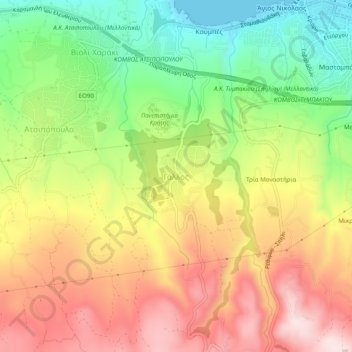
Name: Γάλλος topographic map, elevation, terrain.
Average elevation: 192 m
Minimum elevation: 0 m
Maximum elevation: 386 m
Other topographic maps
Click on a map to view its topography, its elevation and its terrain.
Λαγκά
Grecia > Αποκεντρωμένη Διοίκηση Κρήτης > Περιφερειακή Ενότητα Ρεθύμνης
Λαγκά, Δήμος Μυλοποτάμου, Περιφερειακή Ενότητα Ρεθύμνης, Περιφέρεια Κρήτης, Αποκεντρωμένη Διοίκηση Κρήτης, Grecia
Average elevation: 275 m