
Koka topographic map
Interactive map
Click on the map to display elevation.
About this map
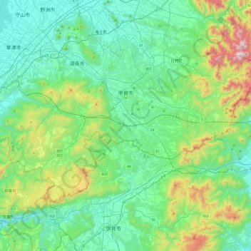
Name: Koka topographic map, elevation, terrain.
Location: Koka, Shiga Prefecture, Kinki Region, Japan (34.79057 135.94090 35.03067 136.42136)
Average elevation: 299 m
Minimum elevation: 49 m
Maximum elevation: 1,202 m
Other topographic maps
Click on a map to view its topography, its elevation and its terrain.
筋海町
Japan > Kinki Region > Kishiwada > 筋海町
筋海町, Kishiwada, Osaka Prefecture, Kinki Region, 596-0054, Japan
Average elevation: 9 m
沼町
Japan > Kinki Region > Kishiwada > 沼町
沼町, Kishiwada, Osaka Prefecture, Kinki Region, 596-0054, Japan
Average elevation: 11 m