
Thank you for supporting this site ❤️
Make a donation
Make a donation
Castleton topographic map
Click on the map to display elevation.
Thank you for supporting this site ❤️
Make a donation
Make a donation
About this map
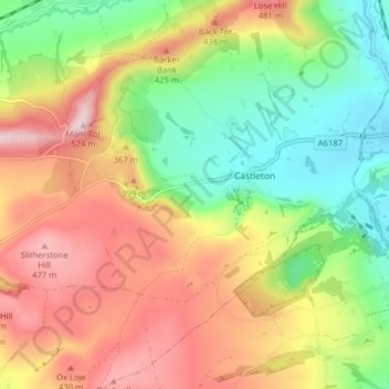
Name: Castleton topographic map, elevation, terrain.
Location: Castleton, High Peak, Derbyshire, England, United Kingdom (53.31701 -1.81804 53.36445 -1.75896)
Average elevation: 326 m
Minimum elevation: 168 m
Maximum elevation: 508 m
Thank you for supporting this site ❤️
Make a donation
Make a donation
Other topographic maps
Click on a map to view its topography, its elevation and its terrain.
Birch Vale
United Kingdom > England > Derbyshire > High Peak > New Mills > Hayfield
Average elevation: 251 m
Thank you for supporting this site ❤️
Make a donation
Make a donation