
Thank you for supporting this site ❤️
Make a donation
Make a donation
Shuangtashan topographic map
Click on the map to display elevation.
Thank you for supporting this site ❤️
Make a donation
Make a donation
About this map
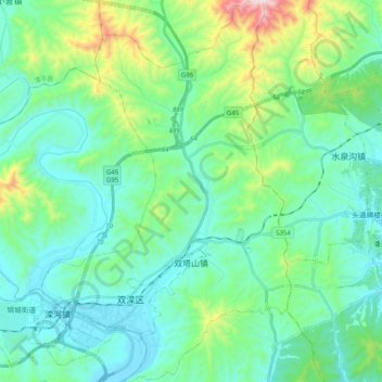
Name: Shuangtashan topographic map, elevation, terrain.
Location: Shuangtashan, Shuangluan District, Chengde, Hebei, China (40.92362 117.73711 41.07437 117.86734)
Average elevation: 519 m
Minimum elevation: 349 m
Maximum elevation: 1,179 m
Thank you for supporting this site ❤️
Make a donation
Make a donation
Other topographic maps
Click on a map to view its topography, its elevation and its terrain.