
Thank you for supporting this site ❤️
Make a donation
Make a donation
Bukavu topographic map
Click on the map to display elevation.
Thank you for supporting this site ❤️
Make a donation
Make a donation
About this map
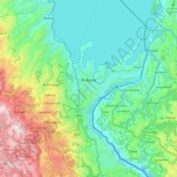
Name: Bukavu topographic map, elevation, terrain.
Location: Bukavu, South Kivu, Democratic Republic of the Congo (-2.56117 28.79369 -2.46016 28.89310)
Average elevation: 1,754 m
Minimum elevation: 1,423 m
Maximum elevation: 2,190 m
Thank you for supporting this site ❤️
Make a donation
Make a donation
Other topographic maps
Click on a map to view its topography, its elevation and its terrain.