
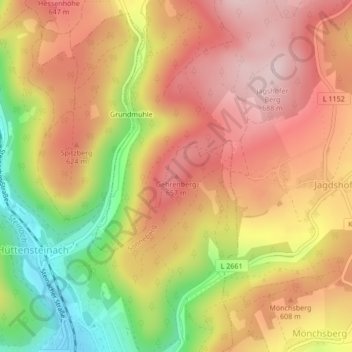
Gehrenberg topographic map
Interactive map
Click on the map to display elevation.
About this map
Name: Gehrenberg topographic map, elevation, terrain.
Average elevation: 567 m
Minimum elevation: 388 m
Maximum elevation: 690 m
Other topographic maps
Click on a map to view its topography, its elevation and its terrain.
96515
Deutschland > Thüringen > Landkreis Sonneberg > Sonneberg
96515, Sonneberg, Landkreis Sonneberg, Thüringen, Deutschland
Average elevation: 579 m
Spechtsbrunn
Deutschland > Thüringen > Landkreis Sonneberg > Sonneberg
Spechtsbrunn, Sonneberg, Landkreis Sonneberg, Thüringen, 96355, Deutschland
Average elevation: 676 m
Haselbach
Deutschland > Thüringen > Landkreis Sonneberg > Sonneberg > Haselbach
Haselbach, Sonneberg, Landkreis Sonneberg, Thüringen, 96515, Deutschland
Average elevation: 604 m
Oberlind
Deutschland > Thüringen > Landkreis Sonneberg > Sonneberg
Oberlind, Sonneberg, Landkreis Sonneberg, Thüringen, Deutschland
Average elevation: 379 m