
Miyaneh topographic map
Interactive map
Click on the map to display elevation.
About this map
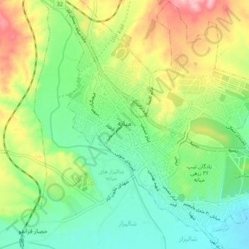
Name: Miyaneh topographic map, elevation, terrain.
Average elevation: 1,118 m
Minimum elevation: 1,056 m
Maximum elevation: 1,227 m
Other topographic maps
Click on a map to view its topography, its elevation and its terrain.
Kandovan
Iran > East Azerbaijan Province > Mianeh County > دهستان کندوان
Kandovan, دهستان کندوان, بخش کندوان, Mianeh County, East Azerbaijan Province, Iran
Average elevation: 1,307 m
Tark
Iran > East Azerbaijan Province > Mianeh County > دهستان کندوان
Tark, دهستان کندوان, بخش کندوان, Mianeh County, East Azerbaijan Province, Iran
Average elevation: 1,508 m