
Thank you for supporting this site ❤️
Make a donation
Make a donation
Roßlau topographic map
Click on the map to display elevation.
Thank you for supporting this site ❤️
Make a donation
Make a donation
About this map
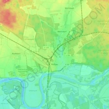
Name: Roßlau topographic map, elevation, terrain.
Average elevation: 71 m
Minimum elevation: 49 m
Maximum elevation: 108 m
Thank you for supporting this site ❤️
Make a donation
Make a donation
Other topographic maps
Click on a map to view its topography, its elevation and its terrain.
Dessau
Deutschland > Sachsen-Anhalt > Dessau-Roßlau
Im Süden grenzt die Stadt an die waldreiche Mosigkauer Heide, in der die Taube entspringt. Dessau liegt auf einer Höhe von 61 m ü. NN. Die höchste Erhebung ist die ca. 110 m hohe ehemalige Mülldeponie (Scherbelberg) im Südwesten der Stadt. Dessau ist von zahlreichen Schloss- und Parkanlagen umgeben und…
Average elevation: 62 m
Innerstädtischer Bereich Nord
Deutschland > Sachsen-Anhalt > Dessau-Roßlau > Dessau
Average elevation: 61 m