
Thank you for supporting this site ❤️
Make a donation
Make a donation
Gunung Mas topographic map
Click on the map to display elevation.
Thank you for supporting this site ❤️
Make a donation
Make a donation
About this map
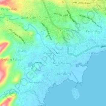
Name: Gunung Mas topographic map, elevation, terrain.
Location: Gunung Mas, Bandar Lampung, Lampung, 34223, Indonesia (-5.46857 105.23625 -5.42857 105.27625)
Average elevation: 34 m
Minimum elevation: -3 m
Maximum elevation: 171 m
Thank you for supporting this site ❤️
Make a donation
Make a donation