
Deinze topographic map
Interactive map
Click on the map to display elevation.
About this map
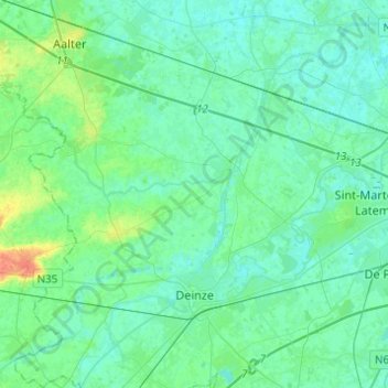
Name: Deinze topographic map, elevation, terrain.
Location: Deinze, Gent, Ostflandern, Flandern, Belgien (50.94714 3.41338 51.10113 3.61315)
Average elevation: 10 m
Minimum elevation: 3 m
Maximum elevation: 38 m
Other topographic maps
Click on a map to view its topography, its elevation and its terrain.
Olsene
Belgien > Ostflandern > Gent
Olsene, Zulte, Gent, Ostflandern, 9870, Belgien
Average elevation: 11 m
Gent
Belgien > Ostflandern > Gent > Gent
Gent, Ostflandern, Flandern, 24-32, Belgien
Average elevation: 12 m