
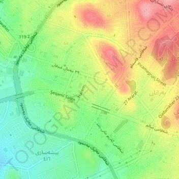
هەندرێن ١٠٩ topographic map
Interactive map
Click on the map to display elevation.
About this map
Name: هەندرێن ١٠٩ topographic map, elevation, terrain.
Average elevation: 795 m
Minimum elevation: 742 m
Maximum elevation: 857 m
Other topographic maps
Click on a map to view its topography, its elevation and its terrain.
Qadir Karam Subdistrict
Iraq > Sulaymaniyah Governorate
Qadir Karam Subdistrict, Chamchamal District, Sulaymaniyah Governorate, Iraqi Kurdistan Region, Iraq
Average elevation: 501 m
Bakrajo
Iraq > Sulaymaniyah Governorate
Bakrajo, Bakrajo subdistrict, Sulaymaniyah District, Sulaymaniyah Governorate, Iraqi Kurdistan Region, 46011, Iraq
Average elevation: 750 m
Topzawa
Iraq > Sulaymaniyah Governorate
Topzawa, Dokan Central Subdistrict, Dokan District, Sulaymaniyah Governorate, Iraqi Kurdistan Region, Iraq
Average elevation: 632 m
Dashti
Iraq > Sulaymaniyah Governorate
Dashti, Mawat Central Subdistrict, Mawat District, Sulaymaniyah Governorate, Iraqi Kurdistan Region, Iraq
Average elevation: 1,009 m
Darbandikhan
Iraq > Sulaymaniyah Governorate
Darbandikhan, Darbandikhan Central Subdistrict, Darbandikhan District, Sulaymaniyah Governorate, Iraqi Kurdistan Region, 46020, Iraq
Average elevation: 584 m
Qada Raniyah
Iraq > Sulaymaniyah Governorate
Qada Raniyah, Chwar Qurna Subdistrict, Ranya District, Sulaymaniyah Governorate, Iraqi Kurdistan Region, Iraq
Average elevation: 1,075 m
Sarnawan
Iraq > Sulaymaniyah Governorate
Sarnawan, Penjwen Central Subdistrict, Penjwen District, Sulaymaniyah Governorate, Iraqi Kurdistan Region, Iraq
Average elevation: 1,393 m
Baste
Iraq > Sulaymaniyah Governorate
Baste, Zharawa Subdistrict, Pshdar District, Sulaymaniyah Governorate, Iraqi Kurdistan Region, Iraq
Average elevation: 1,016 m
Weladar
Iraq > Sulaymaniyah Governorate
Weladar, Tanjaro Subdistrict, Sulaymaniyah District, Sulaymaniyah Governorate, Iraqi Kurdistan Region, 44010, Iraq
Average elevation: 1,323 m
Harawazi 123
Iraq > Sulaymaniyah Governorate
Harawazi 123, Sulaymaniyah, Sulaymaniyah District, Sulaymaniyah Governorate, Iraqi Kurdistan Region, Iraq
Average elevation: 767 m
Fayal
Iraq > Sulaymaniyah Governorate
Fayal, Sulaymaniyah, Sulaymaniyah District, Sulaymaniyah Governorate, Iraqi Kurdistan Region, Iraq
Average elevation: 941 m
وڵوبە ٣٢٦
Iraq > Sulaymaniyah Governorate
وڵوبە ٣٢٦, Sulaymaniyah, Sulaymaniyah District, Sulaymaniyah Governorate, Iraqi Kurdistan Region, Iraq
Average elevation: 786 m
Kotal
Iraq > Sulaymaniyah Governorate
Kotal, Surdash Subdistrict, Dokan District, Sulaymaniyah Governorate, Iraqi Kurdistan Region, 46010, Iraq
Average elevation: 822 m
New Halabja
Iraq > Sulaymaniyah Governorate
New Halabja, Warmarwa Subdistrict, Sharazoor District, Sulaymaniyah Governorate, Iraqi Kurdistan Region, 46018, Iraq
Average elevation: 549 m
Baden
Iraq > Sulaymaniyah Governorate
Baden, Pshdar Central Subdistrict, Pshdar District, Sulaymaniyah Governorate, Iraqi Kurdistan Region, Iraq
Average elevation: 794 m
Sulaymaniyah
Iraq > Sulaymaniyah Governorate
Sulaymaniyah, Bakrajo subdistrict, Sulaymaniyah District, Sulaymaniyah Governorate, Iraqi Kurdistan Region, 46001, Iraq
Average elevation: 977 m