
Romanel-sur-Lausanne topographic map
Interactive map
Click on the map to display elevation.
About this map
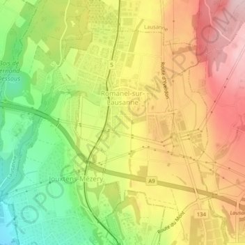
Name: Romanel-sur-Lausanne topographic map, elevation, terrain.
Location: Romanel-sur-Lausanne, District de Lausanne, Waadt, 1032, Schweiz (46.54897 6.59513 46.56976 6.62004)
Average elevation: 604 m
Minimum elevation: 479 m
Maximum elevation: 709 m